


North Carolina’s Outer Banks appear to have emerged from the sea 10,000 to 12,000 years ago, making it a geologic newborn. Although this is only an assumption, the earliest Native Americans came between 1,600 and 2,000 years ago. The Outer Banks can be traced back to the arrival of European explorers.
Early European Explorers
Although the evidence is circumstantial, Amerigo Vespucci was most likely the first European explorer to visit the Outer Banks. If this is true, it happened during his first voyage to the New World in 1499-1500. European explorers thought they were discovering a new continent, but the Outer Banks had long been inhabited by Native Americans of the Algonquin linguistic group, who had lived there for the previous 1,000 years. Because the Indians were not Christians, early Europeans who came into contact with them thought of them as unsophisticated savages.
Nonetheless, these people were far from uneducated. This location served as an administrative hub for the surrounding area, organized into small city-states with a main village where the chief resided. The “city-states” had well-defined political duties and limits. Despite the fact that these tribes were geographically apart, there is substantial artifact evidence that Native Americans from North Carolina’s mountain regions visited and traded here.
The Outer Banks coastline had already been surveyed by a number of voyages, the majority of which were Spanish, by the time the first English military enterprise outpost, often known as the “Lost Colony,” was built on Roanoke Island in 1585. The Native Americans the colonists encountered had most likely met Europeans before or were well aware of their explorations in the area. The first 115 permanent English colonists arrived in Roanoke Island in 1587 to find an uninhabited settlement. The colonists elected to stay, but they dispatched a ship back to England for assistance and supplies.
Because of the looming Spanish Armada, Queen Elizabeth I of England refused to allow a rescue ship to depart, and it wasn’t until 1590 that a ship crossed the Atlantic and arrived on Roanoke Island, only to discover an abandoned colony. The lone hint was a tree etched with the name “Croatan.”
There are no documented accounts of why the Roanoke Island colony failed. The Indians’ first reception was pleasant, according to records returned to England, but their good feeling was later ruined by Governor Ralph Lane’s harsh handed manner towards them. Lane ordered the local town to be destroyed and looted when a silver cup was reported stolen. The Indians, understandably, were enraged by the action and a series of raids on them.
This occurrence, as well as the refusal of local chiefs to aid colonists in settling to their new home, ruined the journey. There is speculation concerning the colony’s fate, but no proof. A map made by the colony was recently re-examined by researchers.
Another idea involves the Robeson County Lumbee Indians. The Lumbees speak a dialect of English that is unique from other dialects. They have traditionally claimed to be the descendants of the Lost Colony’s colonists, and the first English frontiersmen to approach them in the 16th century remarked on their European characteristics and square-framed dwellings. Furthermore, the tribe has a remarkably lengthy history of practicing Christianity.
Roanoke Island Present Day
Although the Roanoke Colony failed, European settlement was unavoidable. The destruction of the Spanish Armada established the British as the preeminent colonial power of the 17th century. After establishing themselves in Virginia, the English began to expand their holdings, and by the late 1600s, they had moved to what are now Dare and Currituck Counties. Colington Island, the earliest permanent colony, was created around 1665. Currituck County was created in 1668, making it one of the state’s oldest counties.
The Age of the Pirates
The Outer Banks provided an ideal sanctuary for pirates, with its ever-shifting shoals and continually opening and closing inlets. Coastal North Carolina was a hotspot of piracy from the late 17th to the early 18th centuries.
Ships sailing between northern ports and southern sugar cane and rum cargoes were easy prey for a well-armed sloop with a captain who knew the area seas because shipping routes bordered the coast of North America. Because North Carolina rulers were enriching themselves by allowing pirates to discharge their cargo in local ports, objections from other colonies fell on deaf ears.
Blackbeard facts
The most notorious pirate, Blackbeard (actual name Edward Teach), made Ocracoke his homeport. After repeated calls for assistance were disregarded, Virginia Governor Spotswood dispatched Lt. Robert Maynard of the British Navy to hunt down and kill or capture Blackbeard. Maynard killed Blackbeard, beheaded him, and mounted his head on the bowsprit of his ship, the HMS Ranger, on November 19th, following a ferocious boarding action. The action took place south of the Outer Banks, off what is now Atlantic Beach.
Blackbeard was not the only infamous name involved in the pirate trade off the coast of North Carolina. Stede Bonnet was as well-known as Blackbeard in his day, and he, too, died in 1718, at the end of a rope in Charleston, South Carolina. The deaths of Blackbeard and Stede signaled the end of the age of pirates. In England, legislation was created that allowed pirates to be tried in municipal tribunals. Prior to such regulations, they had to be returned to England for trial. When combined with stricter enforcement, the outcome was unavoidable.
Lighthouses
Following the ratification of the Constitution in 1789, one of the first actions of congress from the newly created United States government was to fund the United States Lighthouse Establishment and begin the process of building lighthouses to protect shipping along the coastline. The act was the new government’s first transportation bill, and it can be traced back to that act to the lighthouses that line the Atlantic coast from Maine to Florida, as well as the founding of the United States Coast Guard.
Diamond Shoals’ dark seacoast and stormy storms were long renowned as one of the most dangerous areas of ocean on the East Coast. As a result, Congress allocated $44,000 in 1797 to build a lighthouse at Cape Hatteras. The first lighthouse, built in 1803, stood 112 feet above the beach and had a light that could be seen from 18 miles away on a clear day. However, repeated reports suggested that the light was too feeble, prompting Navy Lt. David D. Porter to declare in 1851, “Hatteras Light, the most significant on our coast, is, without a doubt, the weakest light in the world.”
Because of its strategic importance, the Hatteras Lighthouse was demolished during the Civil War, and finances for the rebuilt tower were not authorized until 1868. Despite the fact that $80,000 was appropriated, cost overruns increased the price to $167,000. The government received a light that could be seen 28 miles out to sea and was the tallest lighthouse in the United States at 207 feet. It was an incredible feat of engineering, surviving hurricanes, flooding, and the corrosive effects of salt-laden winds for almost 140 years.
Hatteras Lighthouse
The lighthouse, which was endangered by eroding shorelines, was moved back from the sea in 1999 and currently stands 1,600 feet away from the Atlantic Ocean. The Hatteras Lighthouse, the highest brick lighthouse in the United States, is the most iconic of the four lighthouses that span the Outer Banks. The Ocracoke lighthouse was erected in 1823, replacing an older outmoded lighthouse. Although it is just 75 feet tall, it is an excellent example of early lighthouse construction, with bricks 5 feet thick at the base and 2 feet thick at the top. The Ocracoke Lighthouse, which is still operational today, is the country’s second oldest.
Bodie Island Lighthouse
Government officials advocated a lighthouse north of Cape Hatteras to mark the beginning of the Outer Banks shoals of Pea Island as early as 1838. After a series of setbacks, the first Bodie Island Lighthouse began casting a beam out to sea in 1847. The site, which is located just south of Oregon Inlet, is now submerged. Unfortunately, the contractor did not adhere to the engineer’s recommendations for building the construction on a supported brick base, and the tower began to lean within two years. Attempts to fix the problem were futile, and the construction was abandoned in 1859. However, a replacement tower was rapidly constructed, and a fresh light started illuminating the Atlantic in less than a year. The second Bodie Island Lighthouse had a brief existence. Confederate soldiers destroyed the lighthouse in 1861, fearing that advancing Union troops might utilize it as an observation point.
Currituck Lighthouse
It took the Federal Lighthouse Board five years after the Civil War to agree to replace the light. The Bodie Island Light was relocated to the northside of Oregon Inlet, onto a 15-acre site that is currently on the southern tip of South Nags Head, using brick and other materials from the recently built Hatteras Light.
Construction was completed rapidly, and the first order Fresnel light began beaming out to sea in 1872. The 70-mile stretch between the Cape Henry Light in Virginia and Bodie Island was the final remaining dark patch on the Atlantic Coast when the Bodie Island Light was finished. Construction on the 158-foot Currituck Beach Light in Corolla began in 1873, and it was operational two years later. The lighthouses on the Outer Banks are still in service today, albeit their beacons are automated.
The unusual hue of the structures aids navigation during the day, and each light has its own pattern to guide mariners at night. Climbing is permitted on Currituck Beach, Bodie Island, and Hatteras Light. Currituck Beach is owned and administered by the Outer Banks Conservationists and is accessible all year. Tours and climbing are accessible from late April to Columbus Day on Bodie Island and Hatteras Light, which are both part of the National Park System. All lighthouses charge admission.
The Role Of The OBX During The Civil War
The same characteristics that made the Outer Banks an ideal pirate playground provided the Confederacy with the ideal opportunity to raid coastal ships at the start of the Civil War. Union forces moved with astonishing quickness after recognizing the possible danger. Four months after the start of the war, the North stormed forts protecting Hatteras Inlet, which separated Hatteras Island and Ocracoke. The forts were undermanned and badly built. The Confederate batteries were severely outraged by the Union fleet’s rifled cannons.
Confederate forces at Fort Clark on Ocracoke Island fled to Fort Hatteras. A day later, after hours of intense shelling, the 700 remaining soldiers in Hatteras surrendered. The surrender of Fort Hatteras to Union forces was the first major victory for the North in the Civil War. After taking Hatteras, a series of skirmishes ensued, but the desired prize was Roanoke Island with its direct link to the transportation network of northeastern North Carolina. By February of 1862, Union forces were moving in strength to take the island.
Almost from the time Union forces captured Hatteras, Confederate commanders on Roanoke Island recognized how vulnerable the island was and requested reinforcements and cannons. However, their pleas received little response. When the battle began on February 7th, the Confederate forces, consisting of only 3,000 soldiers and less than two dozen cannons, fought against General Burnside’s 10,000 men and flotilla of gunboats. After a day of heavy shelling, skirmishes and light casualties, the 2,500 remaining southern troops on Roanoke Island surrendered. The capture of Roanoke Island was significant for a number of reasons. Militarily, it allowed the Union Army to take many of the towns and small cities on the surrounding Outer Banks sounds. It also forced the South to commit troops and resources to keep the northern forces from expanding their position.
Boundary Marker Corolla
General Burnside, when confronted with slaves brought to Roanoke to build fortification, declared them contraband of war, a move that effectively freed them. Word spread that any slave that made it to Roanoke Island would be freed; by war’s end the Freedman’s Colony on the north end of the island had a population of 3,000, complete with schools, churches and a town government.
Hunt Clubs
The Outer Banks has always been a vacation retreat, but at one time the seasons were reversed and the fall and winter were times when visitors would travel from cities of the northeast. From 1857, when the Currituck Shooting Club was incorporated, until the 1960s, life in Dare and Currituck Counties revolved around wealthy hunters traveling from the north during winter months and robust farming during the summer months.
Pine Island Hunt Club
Remnants from that time are everywhere. The opulent lifestyle of Edward Collins Knight, who built the Whalehead Club for his wife, is the most apparent reminder. But there are others as well. On Pea Island, the impoundment ponds at the visitor’s center are what remains of a hunt club. The Currituck Club in Corolla, with its award winning golf course, occupies the same land that the first Outer Banks hunt club owned. Until recently, the Pine Island subdivision and Audubon tract was an active hunt club, and the original building remains. The Powder Ridge Gun Club in the Town of Duck is now a bookstore and coffee shop. Even today, the tradition of hunting still exists. The sounds are dotted with duck blinds, and seasonal hunting remains a long-standing tradition for landowners and private hunt clubs.
Whalehead Club
The historic Whalehead Club, built in 1920, in Corolla, North Carolina has been restored to its original grandeur. The former home is now a museum.
The Wright Brothers
After writing to Orville and Wilbur Wright that there were plenty of open beaches and steady winds on the Outer Banks, County Commissioner and Kitty Hawk Assistant Postmaster, William Tate, concluded his letter with, “I assure you, you will find hospitable people when you come among us.” A few weeks later, towards the end of September of 1900, Wilbur Wright showed up unannounced at Tate’s front door. Shortly after, Orville followed and the brothers set up camp at the base of Kill Devil Hill. It was there they discovered what Tate had not included in his letter. “There was no escape. They chewed us clear through our underwear and socks. Lumps began showing up all over my body like hen’s eggs,” Orville wrote to his sister, Katherine, describing the mosquitoes that plagued their camp. Mosquitoes notwithstanding, the Wright brothers had found the testing grounds they needed. The people were indeed, “hospitable,” although somewhat skeptical. This area was isolated from the prying eyes of the press, the winds were brisk and predictable, and the sand was a forgiving landing zone.
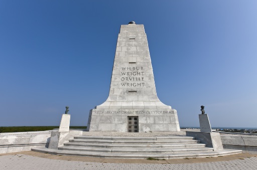
Wright Brothers National Memorial and KFFA airport
The Wright brothers conducted a series of glider experiments during the first three years, 1900 through 1902. It was no accident that they were the first to achieve powered flight. Although neither brother finished high school, they were scientists in the truest sense of the word. They questioned everything, tested and retested, and ultimately proved that the generally accepted formula for lift was wrong. They came up with the basic model for how a propeller moves air. Although we have vastly improved their methods of controlling flight, Wilbur and Orville Wright were the first aviators to understand and develop a practical way to control an aircraft. We still use the same principles today. By 1903 they were ready…but there were delays. Unable to find an engine that met their requirements, they had their bicycle shop manager, Charlie Taylor, build one. Propeller shafts broke, the weather wouldn’t cooperate and it was not until December that they were ready to prove they could fly. Wilbur made the first attempt on December 14th, a three second flight that the brothers rejected as “only a partial success.” December 17th was the next attempt, a cold day.
The first flight of the Wright brothers in Kitty Hawk, NC with the wind gusting to 27mph. At 10:35 a.m., with Wilbur at the controls, the Wright Flyer lifted off the ground and flew. It was a short flight, only 12 seconds, covering just 120 feet, but the flight and the landing were clearly controlled. This flight was recorded in an iconic image snapped by John T. Daniels of the local Lifesaving Service crew. They made three more flights that day, the third lasting 59 seconds and covering 852 feet before a crash landing ended the day. Interestingly, while today the Wright Brothers Monument is in Kill Devil Hills, at the time Wilbur and Orville flew the area was known as Kitty Hawk. The hill that the Monument tops is now in Kill Devil Hills, but it was a migrating sand dune in 1903 and appears to be significantly south of the original location at the time of the flight. The dune has since been stabilized by planting beach grass around its base and up its sides. The grounds and museum of the Wright Brothers Monument tell an extraordinary tale of perseverance, creativity and genius.
The Outer Banks has a rich and diverse history that has a common thread of exploration, ingenuity, adventure and discovery.